
Monday, December 10, 2012
Wednesday, December 5, 2012


Tuesday, November 6, 2012
While this isn't a typical landscape picture, it is interesting. I got a little inspiration in the mail today from Sam to get back to work on my dissertation. So I framed and hung it on the wall above my desk.
 The man in the painting is Frank Hibben. Dr. Hibben is well known in southwest archaeology, mostly for his research into some of the earliest cultures in the New World, notably Sandia, which has been documented at only two sites in North America, both of which Hibben had a hand in. Almost immediately after the initial discovery at Sandia Cave there have been questions about the authenticity of the sites. As part of my dissertation I have been researching the Lucy Site- the second Sandia site. I think that I am pretty close to making an educated guess about the Sandia component at Lucy and will be able to tell you all soon if it is actually a real thing, or if it was faked to support the initial discovery.
Here is a shot of the original point discovery in association with some proboscidean bone:
 And the Albuquerque Tribune article about the discovery:


Here is a shot of the original point discovery in association with some proboscidean bone:


Sunday, October 28, 2012

Wednesday, October 17, 2012


Wednesday, October 10, 2012


Wednesday, September 26, 2012

Thursday, September 20, 2012

Monday, September 17, 2012

Wednesday, August 22, 2012
Drove up from Tucson in a spectacular thunderstorm, and I thought the monsoons were almost over....
It have been raining every afternoon and it rained most of last night and all the washes were flowing which is a sight to see. The rain made for some pretty spectacular vistas this morning. I snapped this picture on my way out to check on some sites this morning:

It have been raining every afternoon and it rained most of last night and all the washes were flowing which is a sight to see. The rain made for some pretty spectacular vistas this morning. I snapped this picture on my way out to check on some sites this morning:

Saturday, August 18, 2012
It has been a very busy couple of days here in the Painted Desert. Last weekend my intern and I went to the Pecos Conference. We had a great time. The intern was able to present a poster which was well received and I got to meet several of my neighboring park archaeology folks. My intern left Monday and my Tech left Thursday. That just leaves me and my GIS intern. I spent Tuesday in Albuquerque working on Dissertation stuff and the rest of the week we had people from the regional GIS office down to help us. As I run the Park's GIS program with no formal training it was nice to have a little professional guidance get us on the right track.
On a good note, my work computer has been fixed. So I can now edit photos and access the internet from work. I also reworked our long distance wireless repeater- it runs through three routers which repeats the signal and occasionally creates a problem, but we seem to have decent wireless at house now. However the power went out yesterday during a spectacular thunderstorm and it took until this morning to return.
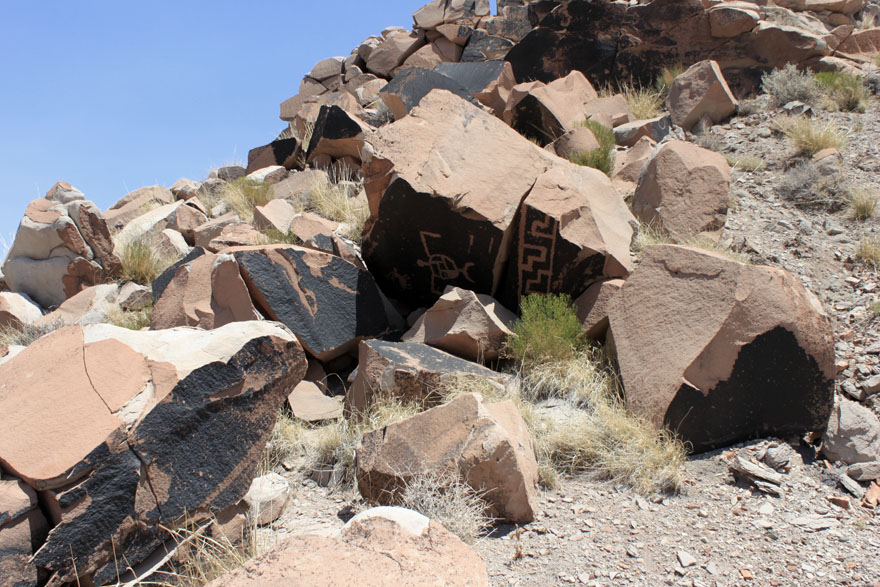
For the photo this week I chose another set of petroglyphs. What makes these interesting is that they are carved into some very dark patina and the are very jumbled. It appears that as part of some mining exploration in the 1950's these panels were bulldozed off the front of the cliff face. It is a prime example of the impacts that we have had on the prehistoric resources in the region.

On a good note, my work computer has been fixed. So I can now edit photos and access the internet from work. I also reworked our long distance wireless repeater- it runs through three routers which repeats the signal and occasionally creates a problem, but we seem to have decent wireless at house now. However the power went out yesterday during a spectacular thunderstorm and it took until this morning to return.
For the photo this week I chose another set of petroglyphs. What makes these interesting is that they are carved into some very dark patina and the are very jumbled. It appears that as part of some mining exploration in the 1950's these panels were bulldozed off the front of the cliff face. It is a prime example of the impacts that we have had on the prehistoric resources in the region.
Tuesday, August 7, 2012

Friday, August 3, 2012
Internet has been down for a while out here. I guess that is a benefit and a curse of living in the middle of nowhere. In the last couple of weeks have have visited a lot of the Park's larger and more prominent sites, including the one pictured below. This site is a large, late Pueblo probably a couple hundred rooms, and some incredible ceramics. The site is perched on a badlands knob and the center of the plaza is eroding out, which you can see in the photo.

As the area around the site is unvegetated badlands there are piles of artifacts everywhere.

We will hopefully be conducting more research on this site in the future. So you might see it again...

As the area around the site is unvegetated badlands there are piles of artifacts everywhere.

We will hopefully be conducting more research on this site in the future. So you might see it again...
Saturday, July 21, 2012
Sorry for the long time between posts, it has been a busy couple of weeks. The hand is mostly healed up, although it still hasn't gotten back it's full mobility. I've had had three crews working in the park, an exotic plant mapping group, a group of masons stabilizing a historic structure, and my field crew mapping sites. After some training in optical surveying a couple weeks ago they "graduated" to the total station. Here they are mapping an eroded Pueblo in the park. I think that they are getting pretty good at generating topographic base maps, the one here involved over 600 shots and the pueblo plots out very well with 10 cm contours.

The monsoons have really kicked up here as well.We have been getting afternoon storms pretty much every day. On our way back from the field yesterday we got caught in a pretty spectacular downpour, complete with lightning, thunder, and hail. The Painted Desert is a sight to see covered with water with streams and arroyos running all over.

The monsoons have really kicked up here as well.We have been getting afternoon storms pretty much every day. On our way back from the field yesterday we got caught in a pretty spectacular downpour, complete with lightning, thunder, and hail. The Painted Desert is a sight to see covered with water with streams and arroyos running all over.
Saturday, July 7, 2012
Had a short week here in the Painted Desert with the Wednesday holiday. But did spent Tuesday and Thursday out with the field crew. We spent Tuesday monitoring the condition of some petroglyphs in the back country and Thursday mapping a small Peublo II-III site right off the park road. Even though it is only a few hundred feet from the road, the initial site recoding had never been finished. It seemed like the ideal opportunity to teach the tech and intern about making maps...

While we do have a total station, I believe that everybody needs to understand basic mapping with an optical instrument first. I have seen far too many errors in total station data which are very obvious if the user understand the basics of what the numbers mean, or even just which direction north is. Whilst we may no longer need to know the horizontal and vertical angles to set up mapping grids, just understanding what they mean will show you instantly if the instrument messed up.
Anybody out there still use a transit for site mapping?
Saturday, June 30, 2012
Good morning folks. Sorry, this post is going to be without pictures this week. It turns out that I split the back of my hand open on Thursday and cut the knuckle almost all the way off my hand. You could actually see the finger bones. I had to get nine stitches to sew the thing back on. I was thinking about putting the picture of that up but it is pretty gnarly. But the doctor seems to have gotten it sewn back on and the bleeding stopped sometime yesterday.
I cut my hand fixing a trailer to load up a UTV to go out into the back country. We had actually gotten quite a bit of rain early this week and were concerned about how passable the roads were. Nick was there to help me get the bleeding stopped and drive me into Holbrook.
But I would like to note, that even though I missed 2 hours of work getting my hand stitched up, we still managed to get the trailer fixed, and went out into the field. We found two new archaeology sites, including a six or so room pueblo, and helped with a property inspection on some lands that should be a part of the park soon.
But archaeology can be dangerous work. I hope that you are always prepared for the worst.
Sunday, June 24, 2012
Sorry, for the lack of posts last week. I gave a lecture in Springerville Monday night and never really caught up with my work. Our new GIS intern has started, but as we still haven't gotten our new computer, so there are four of us sharing two computers. And the GIS intern is using one of them pretty much full time...
But I did get out into the expansion lands Friday:

This is a huge glyph site with panels on both sides of a narrow sandstone gap, including another animal trap glyph. I think that I am going to work up a paper on animal trapping on the Colorado Plateau.

Here is a shot from further down, with Nick's head.
Saturday, June 16, 2012
It has been a busy week. Two Fridays ago we had a group of hoods steal the tool box out of the back of the archaeology truck. Fortunately they didn't steal anything, but it took us a while to find all the tools and repair the tool box. Unfortunately we we getting ready for a weekend in the field with the friends group and didn't have much time in the morning. On Saturday we had a rock art recording trip and while we were out there found this:

It appears to be a Pueblo I canteen that we are in the process of restoring. It was really a fun weekend. But to bracket the week in time we stopped to look at this yesterday...

I think that it is an old railroad tank car used as a stock tank. That is what is great about this job, the archaeological record is very diverse, you never know when you'll be gluing a pot together or studying a rail car.
Tuesday, June 5, 2012
I know it is early in the week, but the intern and I managed to get out of the office for an entire day in the field. We came across four previously unrecorded sites on a high ridge scarp in the park. Three of the sites were small sand stone structures and the fourth was a larger 4-5 room pueblo.

Here is a shot of an intact wall as it erodes off the edge of the scarp. There appears to be just a small sliver of a room remaining on the top of the bluff.

Here is a shot of an intact wall as it erodes off the edge of the scarp. There appears to be just a small sliver of a room remaining on the top of the bluff.
Thursday, May 31, 2012


Friday, May 25, 2012
We had an annular solar eclipse last weekend. As the internet has not really been working this week, I figured I'd put them up now.
And here is a shot of the full eclipse. It reminds me of a Johnny Cash song, Sunday Morning Coming Down, I think...

Did anybody else get to see it? What did you all think?
 |
| Sunset on Tatooine |

Did anybody else get to see it? What did you all think?
Sunday, May 20, 2012
I've been going through a few old photos to try and help set up a professional looking website for myself, with Kacy's help. I came across this photo taken from the inside of Bat Cave looking north across the Plains of San Augustine.

The Bat Cave is often cited as having some of the earliest evidence of corn cultivation. During the last Ice Age a huge lake came up onto the slope below the cave. The hope was to do additional excavations in the cave looking for early Paleoindian deposits.

The Bat Cave is often cited as having some of the earliest evidence of corn cultivation. During the last Ice Age a huge lake came up onto the slope below the cave. The hope was to do additional excavations in the cave looking for early Paleoindian deposits.
Friday, May 18, 2012
Well, the full field crew is finally here. So that meant most of the week was taken up trying to get hiring paperwork completed, house requests done, and finding computers, desks, and equipment. But here is a photo of the crew in action recording petroglyphs with the help of the summer biotech.

The site has several large panels on a small isolated butte on the far eastern edge of the site.

The site has several large panels on a small isolated butte on the far eastern edge of the site.
Saturday, May 12, 2012

Sunday, May 6, 2012
Time for a new photo of the week!
This last week we were able to hike out into the southern portion of the park's piece of the painted desert. To this canyon:
 We had gone out here to look at a series of small eroding pueblos on the mesa tops and visit some petroglyphs with the adjacent landowners, namely the set of panels they called the Moon Dog glyphs for this image:

 Unfortunately, I have to go to training this week, so hopefully the intern will get some good shots while I am gone.
This last week we were able to hike out into the southern portion of the park's piece of the painted desert. To this canyon:


We also found a small wall, perhaps a portion of a granary?

Thursday, May 3, 2012
The archaeology of life and limb:
Had another interesting day this week. On our way out to look at an eroding pueblo we managed to surprise some armed petrified wood hunters and archaeological site looters. One of them attempted to make a run for it, but the other wasn't near his vehicle. We managed to sneak in, get his plate number, and alert the park rangers. After watching them for about an hour the runner returned and we watched them from a hilltop until the rangers arrived.
 As they happened to be on an in holding of private land, the landowner was contacted and the county sheriffs dispatched. We had to identify the artifacts they took and went over the maps of site localities which then had with them. It looks pretty likely that this is something they do often. Hopefully they will get prosecuted.
Had another interesting day this week. On our way out to look at an eroding pueblo we managed to surprise some armed petrified wood hunters and archaeological site looters. One of them attempted to make a run for it, but the other wasn't near his vehicle. We managed to sneak in, get his plate number, and alert the park rangers. After watching them for about an hour the runner returned and we watched them from a hilltop until the rangers arrived.

Saturday, April 28, 2012
A new photo of the week...
It has been a busy week here, got back from the conference Sunday night and then all week at work. We spent most of Wednesday in the field and found three new petroglyph sites and a couple field houses. Not a bad days work.
The first site is a single small panel:

The second site is spectacular. It appears to have later elements, including the basket in the photo below and a animal trap glyph, the second I know of in the park:

The final site is a series of panels including this element. For lack of a better term we called a trojan horse. It is overprinting some earlier glyphs:

Overall a very unique day...
Wednesday, April 25, 2012
Archaeological Society of New Mexico Meetings:
After my talk on the archaeology of the Estancia Basin on Saturday morning had a BBQ lunch and listened to papers all afternoon. The banquet was pretty good and I enjoyed the Bandelier lecture. But the highlight of the conference was the Sunday morning field trip to La Salina....
 Despite the fact I have now worked in the basin for years I have never been to La Salina, which through some trick of the upwelling groundwater is the only sub-basin of the 80 or so which produces pretty pure sodium chloride. The playa has historically been used as a commercial source of salt and extensively used prehistorically. I was able to actually collect some for table salt at home. It is a pretty cool thing to see.
La Salina also has the distinction of being the only land grant granted by the Republic of Texas after they claimed New Mexico still in existence. The ownership was then actually recognized by the congress of the United States in a Private Bill.
After my talk on the archaeology of the Estancia Basin on Saturday morning had a BBQ lunch and listened to papers all afternoon. The banquet was pretty good and I enjoyed the Bandelier lecture. But the highlight of the conference was the Sunday morning field trip to La Salina....

La Salina also has the distinction of being the only land grant granted by the Republic of Texas after they claimed New Mexico still in existence. The ownership was then actually recognized by the congress of the United States in a Private Bill.
Friday, April 20, 2012
Sorry, no picture this evening. But not all of archaeology involves pictures. A fair amount of it involves sitting in cheap motel rooms, fretting about conference papers. And this cheap motel is one of my favorites. The second time I stayed here the owners went on vacation and left me alone in the place for a week. It was actually really nice, though I couldn't get clean towels. The air conditioner in my current room is broken, but it is a beautiful New Mexico evening and having all the windows open is nice.
Although this is the weekend of the Society for American Archaeology meetings in Memphis, I am giving a paper in Moriarty New Mexico. It was an invited lecture, which is nice. But at the same time a little depressing that I have become the expert on something, especially something as odd as a bunch of spear points ringing a lake which has been empty for the last eight thousand years...
Although this is the weekend of the Society for American Archaeology meetings in Memphis, I am giving a paper in Moriarty New Mexico. It was an invited lecture, which is nice. But at the same time a little depressing that I have become the expert on something, especially something as odd as a bunch of spear points ringing a lake which has been empty for the last eight thousand years...
Tuesday, April 17, 2012

Sunday, April 15, 2012
In the first of the Photo of the Week series!
This is a view looking southeast from the extreme northwest corner of the park, about 8 1/2 miles from my office. The large black hill is pilot rock, the highest point in Petrified Forest. The area is beautiful and about as remote as you can get. While most people access this by foot we took the service road which take about 2 hours. A brief survey for archaeology was conducted here several years ago and found sites on both the volcanic plug and surrounding grasslands. The sites mostly consist of slab lined architecture and petroglyphs.
 |
| The view from Pilot Rock |
Good Evening,
I have started this blog for two reasons.
First, I would like to take the idea of the photo of the week to a wider audience. Show, and tell, people what it is that I do as a field archaeologist on a daily basis.
Second, I would like to get back into the habit of writing. Writing things that interest me, discussions of topics I find intriguing. Hopefully that will encourage me to write more and finish up my dissertation.
I intend to update the blog every week, mostly with my archaeology photo of the week.
I hope that somebody else finds it interesting too.
Subscribe to:
Posts (Atom)