
Monday, September 17, 2012

Wednesday, August 22, 2012
Drove up from Tucson in a spectacular thunderstorm, and I thought the monsoons were almost over....
It have been raining every afternoon and it rained most of last night and all the washes were flowing which is a sight to see. The rain made for some pretty spectacular vistas this morning. I snapped this picture on my way out to check on some sites this morning:

It have been raining every afternoon and it rained most of last night and all the washes were flowing which is a sight to see. The rain made for some pretty spectacular vistas this morning. I snapped this picture on my way out to check on some sites this morning:

Saturday, August 18, 2012
It has been a very busy couple of days here in the Painted Desert. Last weekend my intern and I went to the Pecos Conference. We had a great time. The intern was able to present a poster which was well received and I got to meet several of my neighboring park archaeology folks. My intern left Monday and my Tech left Thursday. That just leaves me and my GIS intern. I spent Tuesday in Albuquerque working on Dissertation stuff and the rest of the week we had people from the regional GIS office down to help us. As I run the Park's GIS program with no formal training it was nice to have a little professional guidance get us on the right track.
On a good note, my work computer has been fixed. So I can now edit photos and access the internet from work. I also reworked our long distance wireless repeater- it runs through three routers which repeats the signal and occasionally creates a problem, but we seem to have decent wireless at house now. However the power went out yesterday during a spectacular thunderstorm and it took until this morning to return.
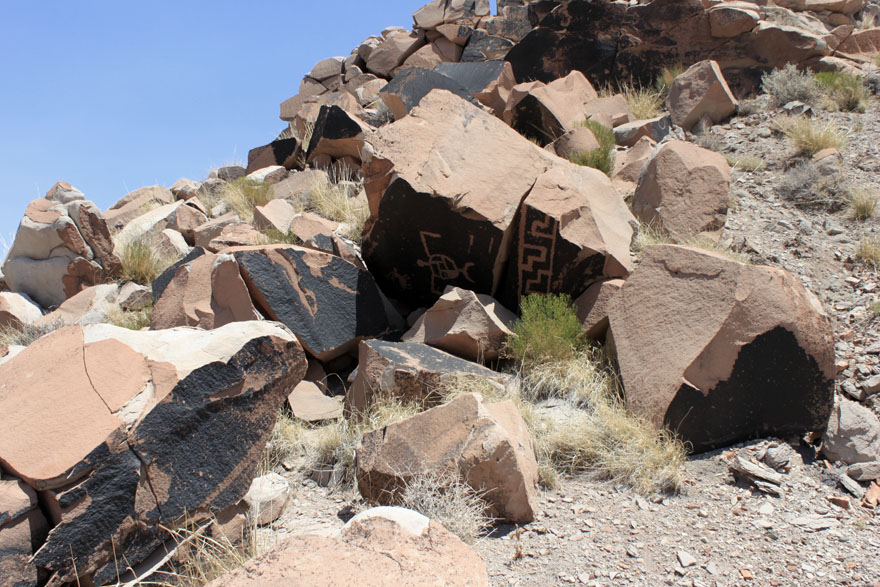
For the photo this week I chose another set of petroglyphs. What makes these interesting is that they are carved into some very dark patina and the are very jumbled. It appears that as part of some mining exploration in the 1950's these panels were bulldozed off the front of the cliff face. It is a prime example of the impacts that we have had on the prehistoric resources in the region.

On a good note, my work computer has been fixed. So I can now edit photos and access the internet from work. I also reworked our long distance wireless repeater- it runs through three routers which repeats the signal and occasionally creates a problem, but we seem to have decent wireless at house now. However the power went out yesterday during a spectacular thunderstorm and it took until this morning to return.
For the photo this week I chose another set of petroglyphs. What makes these interesting is that they are carved into some very dark patina and the are very jumbled. It appears that as part of some mining exploration in the 1950's these panels were bulldozed off the front of the cliff face. It is a prime example of the impacts that we have had on the prehistoric resources in the region.
Tuesday, August 7, 2012

Friday, August 3, 2012
Internet has been down for a while out here. I guess that is a benefit and a curse of living in the middle of nowhere. In the last couple of weeks have have visited a lot of the Park's larger and more prominent sites, including the one pictured below. This site is a large, late Pueblo probably a couple hundred rooms, and some incredible ceramics. The site is perched on a badlands knob and the center of the plaza is eroding out, which you can see in the photo.

As the area around the site is unvegetated badlands there are piles of artifacts everywhere.

We will hopefully be conducting more research on this site in the future. So you might see it again...

As the area around the site is unvegetated badlands there are piles of artifacts everywhere.

We will hopefully be conducting more research on this site in the future. So you might see it again...
Saturday, July 21, 2012
Sorry for the long time between posts, it has been a busy couple of weeks. The hand is mostly healed up, although it still hasn't gotten back it's full mobility. I've had had three crews working in the park, an exotic plant mapping group, a group of masons stabilizing a historic structure, and my field crew mapping sites. After some training in optical surveying a couple weeks ago they "graduated" to the total station. Here they are mapping an eroded Pueblo in the park. I think that they are getting pretty good at generating topographic base maps, the one here involved over 600 shots and the pueblo plots out very well with 10 cm contours.

The monsoons have really kicked up here as well.We have been getting afternoon storms pretty much every day. On our way back from the field yesterday we got caught in a pretty spectacular downpour, complete with lightning, thunder, and hail. The Painted Desert is a sight to see covered with water with streams and arroyos running all over.

The monsoons have really kicked up here as well.We have been getting afternoon storms pretty much every day. On our way back from the field yesterday we got caught in a pretty spectacular downpour, complete with lightning, thunder, and hail. The Painted Desert is a sight to see covered with water with streams and arroyos running all over.
Saturday, July 7, 2012
Had a short week here in the Painted Desert with the Wednesday holiday. But did spent Tuesday and Thursday out with the field crew. We spent Tuesday monitoring the condition of some petroglyphs in the back country and Thursday mapping a small Peublo II-III site right off the park road. Even though it is only a few hundred feet from the road, the initial site recoding had never been finished. It seemed like the ideal opportunity to teach the tech and intern about making maps...

While we do have a total station, I believe that everybody needs to understand basic mapping with an optical instrument first. I have seen far too many errors in total station data which are very obvious if the user understand the basics of what the numbers mean, or even just which direction north is. Whilst we may no longer need to know the horizontal and vertical angles to set up mapping grids, just understanding what they mean will show you instantly if the instrument messed up.
Anybody out there still use a transit for site mapping?

While we do have a total station, I believe that everybody needs to understand basic mapping with an optical instrument first. I have seen far too many errors in total station data which are very obvious if the user understand the basics of what the numbers mean, or even just which direction north is. Whilst we may no longer need to know the horizontal and vertical angles to set up mapping grids, just understanding what they mean will show you instantly if the instrument messed up.
Anybody out there still use a transit for site mapping?
Subscribe to:
Posts (Atom)